CONSERVATION OF NATURAL AREAS
This section describes three projects in which I have been involved in recent years.Project 1802 - Saving A'Nowaghi (see immediately below)
The Ecological Monitoring and Assessment Network (EMAN)
The Forest City Tree Project - growing and giving away trees
PROJECT 1802
In 1997 my wife Patricia and I began Project 1802, a cooperative venture with the Kettle Creek Conservation and Upper Thames River Conservation Authorities. The name of the project derives from the year 1802. The first documented record of a tree being felled by European settlers in this area dates to 1803. The goal is therefore to reclaim natural land.
The focus of the project is the 50 hectare site we call A'Nowaghi Forest Ponds, a provincially significant wetland. "A'Nowaghi" is an Iroquoian word meaning "Place of the Turtles." A'Nowaghi is full of turtles since it contains a total of 18 ponds (mostly kettles) and swamps.
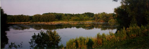 A'Nowaghi as seen across the Regina Mundi Pond
To our knowledge, a complete, five-kingdom survey has never been attempted on any kilometer-scale piece of land on this planet. The survey began in May of 1997 and has involved approximately two dozen experts, from biologists to foresters to geologists and chemists. Although we have carried out most of the identification work ourselves, there are several "difficult" groups of organisms that require expert assistance. For example, Dr. James Phipps, a plant scientist at the University of Western Ontario (UWO) and an expert on hawthorns (an extremely difficult group) has found fifteen species of Crategus in A'Nowaghi, an exceptionally high richness for this genus. Dr. Ian Smith of Agriculture Canada's central agricultural research facility in Ottawa has identified some 40 species of water mites in the area. Some of the experts, such as Dr. Stan Caveney of the UWO Zoology Department, have also spot-checked our identifications in order to ensure accuracy. At the present time (August 14 1999), our "scoreboard" looks like this:
- Monera (Cyanobacteria plus bacterial morphospecies) 24
- Protista (Chlorophyta, Rhizopoda, Ciliata, etc.) 172
- Fungi (macrofungi, pathogenic microfungi, and lichens) 146
- Animalia (from Rotifera to Chordata) 499
- Plantae (from Bryophyta to Angiospermatophyta) 360
- Total species found to date 1,201
We expect, ultimately, to record close to 2000 species, there being perhaps about 3000 on site, not counting metabolic species of bacteria. By project end in 1999, we expect to have logged 99 percent of the macrospecies (1 cm diameter or larger) in the area, 75 percent of the mesospecies (between 1 mm and 1 cm), and perhaps as much as 50 percent of the microspecies (less than 1 mm).
To view the list, see Species
In addition to the life inventory, Project 1802 has other major components, including geology and hydrology, vegetation dynamics, local history, landowner cooperation, and public education. Project 1802 is overseen by a steering committee struck by the Kettle Creek CA. The committee has representatives from the two presiding watershed authorities, as well as from local conservation groups, civic bodies, and landowners. Under the committee's guidance, Project 1802 will formulate a management plan designed to protect and enhance the A'Nowaghi Forest Ponds complex. Already, the Kettle Creek Authority has agreed to stop cutting the South Meadow (see map) and has posted the Kirk-Cousins parcel with No Hunting signs. Local private landowners have also agreed to this signage policy.
ancient history
A'Nowaghi is perched on the Westminster Moraine, once a melting site for the Erie Ice Lobe about 9000 years ago. Huge blocks of ice, calved from the glacier, splashed into a shallow lake of meltwater that once covered the area. The lake drained south into the proto-Mississippi system, the route east being blocked by a huge ice dam. Some of the icebergs that fell from the glacier were immense, much larger than the lake was deep (less than 30 meters). Consequently, they did not float away, but sat on the lake bottom. Icebergs that size take hundreds of years to melt. As they melted, the blocks of ice gradually assumed a rounded shape. Meanwhile the glacier rained boulders and gravel, then sand, silt and clay, into the lake. These sediments filled the spaces between the icebergs and the lake bottom, building a network of ridges that cradled the bergs and lined their rounded flanks with clay. Here were the future upland forests, kettle ponds, and swamps of A'Nowaghi.
The Erie Lobe finally retreated, forming one more moraine a few kilometers away, then melting entirely. The ice dam to the east also melted and area waters began to drain into the proto-St. Lawrence system. The new terrain was clothed in Black Spruce, part of a boreal forest that extended most of the way down the Mississippi Basin, covering Appalachia to the east, as well. As the climate gradually warmed, deciduous trees began an invasion form the south. They advanced north to the Great Lakes, ultimately going a little beyond Lakes Erie and Ontario in the east, but stopping short of Lake Superior in the west.
North America was been populated by humans long before the recent ice age began. We know nothing of habitation or use patterns of A'Nowaghi by native people prior to the European invasion, but in the 17th and 18th Centuries, the general area was inhabited by Iroquoian-speaking people called the Attawandaron people. It is highly likely that its unusual geography and great richness of species would have attracted not only hunters and gatherers to the area, but it may have been regarded as a sacred site, as well. The key role played by the turtle in native religion, as well as the unusually high turtle population (mainly Eastern Painteds and Snappers) might well have earned the name "A'Nowaghi" ( = a'nowa/turtle and ghi/place of). A'Nowaghi has a high density of plants known to play a role in native medicine.
With the arrival of European settlers in the early Eighteenth Century, about 85 to 95 percent of the arable land in Middlesex and Elgin Counties was cleared for agricultural purposes. The only trees left standing were along river and creek valleys, as well as in the few moraine complexes of these counties, the geography there being too hilly for agriculture.
geography and vegetation
The accompanying map shows the core area of A'Nowaghi outlined with a dotted boundary. Land parcels are enclosed by dashed lines, with corporate owners designated by acronyms and private owners by symbolic codes. A railroad (CNR) runs through it. All land west of the railroad is in corporate/public hands, while all land east of the line is privately owned.
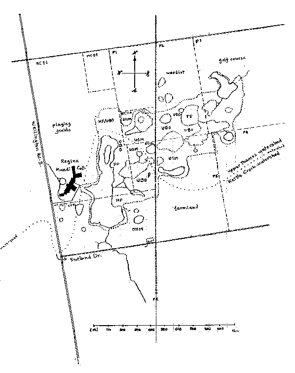
A system of trails (not shown) gives access to all the major habitats within A'Nowaghi. These include upland beech/oak forests (UBO), upland second growth scrub meadows (USM), open herbaceous meadows (OHM), hawthorn/hickory lowland forests (HF), a pine plantation (PP), open swamps and ponds (solid boundaries), tree-invaded swamps (dotted boundaries), and a large tamarack bog. A dotted line indicates the main vegetation boundary between woody areas and herbaceous ones.
As a general rule, the northern (UTRCA) watershed of A'Nowaghi supports a somewhat larger number of temperate/boreal species than does the southern (KCCA) watershed, which has more temperate/southern species. The reason for this slight but noticeable division may lie in a degree or two of equivalent northerly (or southerly) latitude produced by landslope and consequent insolation of the two watershed components.
The future course of vegetation in A'Nowaghi will be determined to a large extent by present patterns. For example, the southern UBO, now nearing maturity, will expand slowly into the OHM to the south (the South Meadow), even as the upland scrub meadows, already invaded by pioneering ash and maple, develop into UBO forests. The Pine Plantation, which consists of a few thousand Eastern White Pine, was planted nearly thirty years ago by a well-meaning individual who did not realize that the project was doomed by the heavy clay moraine soils of the area. Already, large central sections of the plantation have been taken over by American Elm and everywhere you look on the needle-carpeted floor, deciduous pioneers are groping for sunlight.. There will be almost nothing left of the pines within 50 to 75 years.
Groundwater is exceptionally slow in the A'Nowaghi area, owing to the heavy clay soil. Most of the drainage to south or north is underground, although traces of an ephemeral stream draining the large (Regina Mundi) pond to the south has been found. Judging from landforms, this stream may never have flowed with open water, except for a trickle here or there along its course. This could mean that the native fish populations of A'Nowaghi (mainly sticklebacks, madtoms, and various species of minnow) are all ice-age relicts.
A'Nowaghi as a research site
Many professional biologists who have visited the site have remarked on its richness and general scientific interest. For example, Dr. Laszlo Orloci, a well-known UWO plant scientist, has declared the area's potential as a "prime research site." Dr. Ron Martin, an environmental chemist at UWO, has already launched some graduate student projects to assess the presence and ecological role of heavy metals and phospholipids in some of the area's ponds.
It may be that we can get the nearby University of Western Ontario to develop a stake in the area and to encourage non-invasive studies of its biological and other elements. A'Nowaghi may also become a monitored site in the Mixedwood Plain bioprovince of Canada. The Ecological Monitoring and Assessment Network (EMAN) has over a hundred sites across Canada, set up to answer the questions: What is changing and why?
how to get there
A'Nowaghi lies just inside the "core" of the Eastern Deciduous Forest Zone as typified by the Ohio Valley flora and fauna. It is located about 20 km north of Lake Erie and 9 km south of the centre of London. The site occupies most of the land east of Wellington Road between Westminster Drive and Scotland Drive and extending for one kilometer behind (east of) Regina Mundi College. To get there, follow Wellington Road to Scotland Drive, then turn east and proceed one half kilometer as far as the CNR railway tracks. Just before the tracks there is a small parking lot and a sign that reads KIRK-COUSINS MANAGEMENT AREA. Covering about one quarter of the total A'Nowaghi site, this management area includes a mature deciduous forest and several ponds of interest.
Visitors are welcome to enjoy any part of A'Nowaghi west of the railroad tracks, but the eastern half is a NO GO zone for the time being. We ask you to respect the rights of the private landowners in this zone. Until the management policy is in place and all land use issues within A'Nowaghi are settled, visitors who cross the railroad tracks may be subject to prosecution for trespassing.
a quick tour of A'Nowaghi
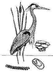
Leave the parking lot and walk north across the meadow, bearing to your left so as to enter the forest along the main trail at the west end of the meadow edge. On the way, you will see two kettle ponds to the east on your right, one large and one small. On your left, to the west, you will see the large Regina Mundi Pond, which will be a major target for bioremediation in the future. At the moment, it receives treated sewage from the high school, a situation which has caused flooding and, possibly, emulsion/suspension of clay sediments, blocking light to the bottom, cutting primary production, and reducing overall species richness. In spite of the pollution, the pond is lined with broad-leaved cattails and other marsh flora. It continues to be visited by the Great Blue Heron and Great Egret (during its migration), as well as Canada Geese, spotted Sandpiper and numerous ducks from over half a dozen species. Muskrats live near the north end and mink prowl its shores.
As you enter the Hickory/hawthorn forest, look about and notice the numerous clumps of woody plants. These include the invasive buckthorns, pioneering hawthorns and leaders of the future forest, including elm and ash. As soon as you enter the Hickory /hawthorn forest on a hot day, you will be immersed in natural air-conditioning. Veerys and robins may hop ahead of you on the path, rosy russulas and blushers sprout from damp soil, and all about you great shags of hickory bark hang in romantic festoons.
You will come to a small foot bridge under which passes an ephemeral stream that drains Pond Epsilon to your right into Pond Beta on your left. (We have given Greek letter names to these bodies of water to avoid prejudicing the future name selection process.) In this small opening, we have seen numerous species of butterfly such as the Mourning Cloak and Question Mark butterfly, as well as the Ruby-throated Hummingbird, American Redstart and other birds. Listen carefully and you may hear the calls of various frogs, the banjo-twang of the Green Frog, the complaint of the Leopard Frog and the trill of the Grey Tree Frog. (At the current count, A'Nowaghi is home to fifteen species of herptiles.)
The path then leads up a small hill into one of A'Nowaghi's principal forested areas. Here are 60 year old American Beeches, tall Black Cherries, heavy Red and White Oaks, as well as White Ash, Sugar Maple, and Basswood. The understorey is still somewhat crowded with Ironwood, Blue Beech, and Juneberry. Still smaller are the bushes of Maple-leaved Viburnum and Spicebush presiding over Wild Geranium, Tall White Lettuce, and many ferns and mosses. In the spring this area is filled with the flowers of Trout Lily, Spring Beauty, Wood Violet, Buttercup, and Yellow Mandarin, to name just a few. Here too you may see a Raccoon sleeping in a tree, watch a Hairy Woodpecker at work, follow the progress of Squirrels along their aerial highways through the canopy. (Needless to say, the real animal action is at night when skunks and possums go on the prowl and the Great Horned Owl gives fair warning of the hunt to come.)
Follow the main trail to the east and you will pass through these pleasant glades until you arrive at a depression we call the Hollow. Here grow eight different species of fern, including the Sensitive Fern, Christmas Fern, Royal Fern, Rattlesnake Fern, Cinnamon Fern and others. Numerous species of moss drape rotting logs in the shade of Yellow Birch, Shagbark Hickory, and silver Maple. The main trail now bends to the north, crossing the east end of Swamp Theta, a large tree-invaded tract, then climbing a ridge and descending into another arm of the swamp where a pontoon bridge (constructed by the shop class of Regina Mundi) provides a convenient stopping point.
From the Pontoon Bridge, you may see Black Ash, silver Maple, Red Maple and other water-loving species, with Witch Hazel, Bebb Willow, and Swamp Rose lining the shores, some venturing into the swamp itself. There are Cattails aplenty here, as well as Wool Grass, Three-way Sedge, Water Hemlock (don't eat it!), and various species of Bulrush. The pontoon bridge is also an ideal bird-watching site. At the current count, A'Nowaghi is the migratory or seasonal home to 96 species of birds.
Beyond the bridge, the trail leads to a another small upland forest on a ridge of land. From here you may look west into a huge kettle we call the Amphitheatre, a perfect bowl 150 meters wide, the bottom being a fern hummock swamp. To the east, you may follow the trail along a ridge just south of Pond Delta. We cannot refrain from calling it Turtle Pond, for it has an enormous population of turtles. On a hot day, you may see a hundred or more out sunning themselves. Snapping turtles, some of them of record size (about 4' long) may be seen gliding along pond bottoms. Don't be surprised if one looks up at you as though it had lunch in mind!
Continue the tour on your own, following where the trails lead and bearing in mind the following simple rules:
1. Do not cross the railroad.WWW Note:2. Do not litter.
3. Keep dogs on a leash.
4. Never for any reason step off the trails.
5. Leave insects and other animals strictly alone.
6. Treat each plant as though it were Poison Ivy. (There are three varieties of this plant in A'Nowaghi, anyway.)
7. Don't tell your friends about the place. (It can only take so much human presence before it begins to lose species.)
A website describing the work at A'Nowaghi will appear early next year, accessible from this site and with an address of its own. We plan to publish the life inventory data on this website, as well as to describe the management plan and other important details of this key natural area of Ontario's "deep south."
In 1993, following the success of the Canadian acid rain research program in
identifying the threshold of sulphate load that produces acidification of
northern lakes, Environment Canada set up the Ecological Monitoring and
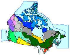
Assessment Network. Canada is divided into fifteen bioprovinces, the
southernmost being the Canadian section of the eastern deciduous forest of
North America. This province, called the Mixedwood Plain, has nine monitoring
sites such as the Long Point Biosphere Reserve, the Niagara Escarpment, the
Queens University Biological Station, and Mont St. Hillaire in Quebec.
Every year, the EMAN holds the National Science Conference, the next one being
in Victoria, British Columbia in January, 1999. Hundreds of biologists and
other scientists come to this conference to share their findings and to
coordinate future research. At this conference, scientists find not only a
ready audience for their work, but a sense of sharing and appreciation that
goes beyond the usual scientific gathering. From each conference a new sense
of "what's changing" emerges, not to mention the "whys" that motivate some of
the most interesting research being conducted in Canada these days.
THE ECOLOGICAL MONITORING AND ASSESSMENT NETWORK (EMAN)
THE FOREST CITY TREE PROJECT
 Every year I grow and give away between 200 and 300 trees and
shrubs to people in Ontario and across Canada. These are native
hardy trees, some rather uncommon, mostly from the "Carolinian"
flora of southern Ontario. The offerings in any one year will involve
a subset of the following: American Beech, American Chestnut,
American Plum, Bitternut Hickory, Black Ash, Black Cherry, Black
Gum, Black Locust, Blue Beech, Catalpa, Crab Apple, Cucumber
Magnolia, Eastern Flowering Dogwood, Hackberry, Honey Locust,
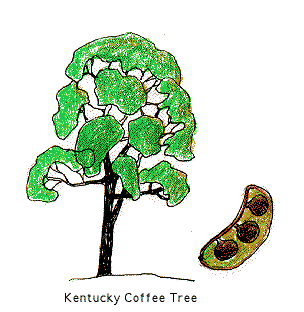
Hoptree, Kentucky Coffeetree, Maple-leaved Viburnum, Ohio
Buckeye, Pawpaw, Redbud, Red Mulberry, Red Oak, Rough-leaved
Dogwood, Sassafras, Scarlet Oak, Shagbark Hickory, Spice Bush,
Sycamore, Tulip Tree, Umbrella Magnolia, Virginia Creeper, Witch
Hazel and others.
Every year I grow and give away between 200 and 300 trees and
shrubs to people in Ontario and across Canada. These are native
hardy trees, some rather uncommon, mostly from the "Carolinian"
flora of southern Ontario. The offerings in any one year will involve
a subset of the following: American Beech, American Chestnut,
American Plum, Bitternut Hickory, Black Ash, Black Cherry, Black
Gum, Black Locust, Blue Beech, Catalpa, Crab Apple, Cucumber
Magnolia, Eastern Flowering Dogwood, Hackberry, Honey Locust,
Hoptree, Kentucky Coffeetree, Maple-leaved Viburnum, Ohio
Buckeye, Pawpaw, Redbud, Red Mulberry, Red Oak, Rough-leaved
Dogwood, Sassafras, Scarlet Oak, Shagbark Hickory, Spice Bush,
Sycamore, Tulip Tree, Umbrella Magnolia, Virginia Creeper, Witch
Hazel and others.